Sunday, August 27, 2017

Paths to my personal best

I took another run today at Tiger Mountain, following West Tiger 3 from the road leading to the trail head to the terminus at 2,522 feet. It started out easy, but after a few heat flashes, it became difficult, and finally, grueling. Washington Trails Association says it isfive miles round trip and a gain of 2,100 feet. Based on today's experience, this will likely be my training trail for the foreseeable future. I probably walked more than five miles because of where I parked, but I will go with WTA figures.

The lighting was very favorable, so I engaged in a favorite pastime -- capturing images of the trail, which follow.


Distance: 5.5 miles, or 10.4 km *
Elevation gain: 2,100 feet
Load: 13-pound pack
Notes: Forgot bug spray again; the bugs are out, and when I sit down to rest they find me. Lot of sweating, but I hydrated enough that I didn't get charlie horses; however, I think I came close on one occasion when I was trying to get my boots off. Statistics: Washington Trails Association said this was a five mile hike, but the trailhead sign said it was 6 to the lookout. I've added to that a half-mile to the car, which is probably understated.

Stats for year to date:
Distance: 269.94 km
Elevation Gain: 18,270 feet

Tuesday, August 15, 2017

Another running tab . . .

Aug. 15, 2017: Little Si

View of Mount Si from point near summit of Little Si

Distance: 4 miles, 6.4 km
Load: 12 pounds
Elevation gain: 1,300 feet
Notes: With Mary Jane Gibson. Leisurely, sluggish hike. 2.5 hours to the top; 1.5 hours back. Cool weather except at the top and at the end of the hike.

States for year to date:
Distance: 259.54 km
Elevation Gain: 16,170 feet

Thursday, August 3, 2017

Feeding wildlife, meeting homeless, etc. Week 7-31-17

Start of the High Point Trail

The banquet

Normally, I try not to feed the wildlife when I'm hiking, but it was that kind of day. I felt sluggish and low energy, it was muggy, and the wildlife was ravenous. My  balaclava was soaked and not admitting another drop of sweat. When a hot flash forced me to sit down, the eau de Robert was all it took for a thousand mosquitoes, and biting flies of all sizes to descend on this stationary buffet. They were not taking "no" for an answer and I was too tired to swat them all.

I had hiked for only 45 minutes and just passed the sign for the Talus Rock Trail when I realized my body was not willing to go any farther. I turned back. Every time I paused to take a snapshot of the scenic trail, the critters found me again and the feeding frenzy resumed. It didn't stop until I made it back to the trailhead.

Tent City 4

Just before I made it to the freeway, I noticed that there was a building behind a line of cars, and I pulled over to see what it was. I wasn't expecting to see a homeless camp.

The first tent is the "office;" the rest are domiciles that point the way to another hiking trail.

Tent City 4 is located close to the end of the Exit 20 offramp on I-90 enroute to the trailhead.

My first reaction when I came to the Tent City 4 sign was wondering whether I was trespassing. But the lady reading her book at the entrance of the first tent/building waved me in. Afterward, I met Wendell, the on duty E.C., and Sam, the camp advisor. Sam explained that drugs and alcohol are banned in the camp; residents frequently provide bottled water to hikers who pass by; and that many of the residents have jobs. They bicycle to a nearby bus stop to get to work.

The camp has a TV and has a gasoline-powered electrical generator. There's a tent kitchen for preparing foods.

Operational needs include

  • Gasoline -- including gas cards sold by gasoline stations
  • Clean Blankets
  • Bottled Water
  • Hot dinner meals (www.sharewheel.orgwww.sharewheel.org for the calendar)
  • 33-gallon trash bags
  • Batteries AAA and D sizes
  • 10-by-10 foot tents
  • Office Depot gift cards for supplies
  • Ibuprofen
  • Printer ink cartridges for Epson Model #220 (blk/colors)

Other scenes this day:

Part of the trail out


Part of the trail back

Distance: tbd
Elevation gain: tdb
Load: 16 pounds
Stamina: Weak; hot flashes combined with warm weather; lots of sweating; needed bug spray. Turned back just past the Talus Rock Trail sign.

Other hikes this week.

July 31: Chocolate Box; Greenlake

Distance: 2.8 miles, 4.48 km to Chocolate Box
Distance: 2 miles, 3.2 km around half of Green Lake (estimate)
Elevation gain: 200 feet
Stamina: coming up hill from downtown I felt quite fatigued
Companions: Larisa and her twin granddaughters (8 years old) who came to Seattle by bus.

States for year to date:
Distance: 253.54 km
Elevation Gain: 14,870 feet


Wednesday, July 19, 2017

Running tab...First Rainier for 2017

Morning on the trail up Little Si

July 19, 2017

Rattlesnake Ledge with Mary Vesper. Mary made it two-thirds of the way. I went on ahead and returned. Next time I plan to wear a 20-pound weight vest plus my backpack.
After hike activity:  XXX Root Beer in Issaquah with Shirley Ganse and Mary.
Distance: 4 miles = 6.4 km
Elevation gain: 1,160 feet
Time: 90 minutes up; one hour down
Load: 15 pounds, approximately.
Stamina: Varied; hot flashes enroute. Cool beeze at the top helped. Shared a trekking pole with Mary on way down.

July 20, 2017

Pike Place Market  (Lowell's restaurant) with Jamie Marsden. Viewed infinity exhibit at SAM; buffet at Dawat grill.
Distance: 2.8 miles, 4.48 km
Elevation gain: 200 feet
Load: Negligible
Stamina: Good, but a little tired going back up hill

July 23, 2017

Ivar's Acres of Clams and Cal Anderson Park area, distributing sack lunches
Distance: 3.6 miles, 5.76 km
Elevation gain: 300 feet
Load: Negligible
Stamina: Improved stamina coming up hill

July 26 hiking companions Mary Vesper and Jamie Marsden


July 26, 2017

Little Si, Christ Our Hope Catholic Church. Companions were Mary Vester and Jamie Marsden. Trail was dusty; light was mottled, and we were tired, making hike a little dangerous at times. Mary fell, while descending some rocks, but was uninjured. Warm day.
Distance: 6.6 miles, 10.56 km
Elevation gain: 1,500 feet
Load: 14 pounds for Little Si portion
Time: Little Si, 4.5 hours
Stamina: Hiked slow; several hot flashes. stamina fair aside from hot flashes

States for year to date:
Distance: 245.86 km
Elevation Gain: 14,670 feet

The First Rainier.


Friday, July 14, 2017

Several conditioning hikes; Map My Hike fails.

Today, the tenuous credibility the Map My Hike software might have had with me vanished. I hiked Rattlesnake Ledge. Map My hike said it was 2.43 miles to the summit, but only 2.07 miles coming down. At the trailhead, the distance to the top is listed at 1.9 miles. Although Map My Hike's descent was close on the descent, it was 20 percent off on the ascent. The altitudes were also surprisingly inaccurate. Washington Trails Association (WTA) lists the sumit at 2,078 feet.

Map My Hike's elevation figures for Rattlesnake Ledge

Map My Hike's elevation chart shows a gain of only 984 feet, compared to WTA's 1,160 feet. It's maximum elevation of 1,941 feet is not only less than WTA's 2,078 -- it also shows the maximum elevation (c. 1939) occurring prior to the summit.


Despite my repeated disappointment with the Map My Hike software, today's hike went well. I began sluggish and sat for a moment at the trailhead until a moment of fatigue passed. When I started hiking, my legs felt sluggish. But that diminished, although I found myself breathing heavily. But that came and went as well. Halfway through the hike I had reached a new speed limit since my medical treatments: 132 heartbeats per minute. I ascended Rattlesnake in 90 minutes, despite breaks along the way. When it came time to descend, it took me only 70 minutes. I noticed on the descent a weakness early in that portion of the hike, but that was immediately followed sweating, and I knew I was just having another "silent" hot flash.

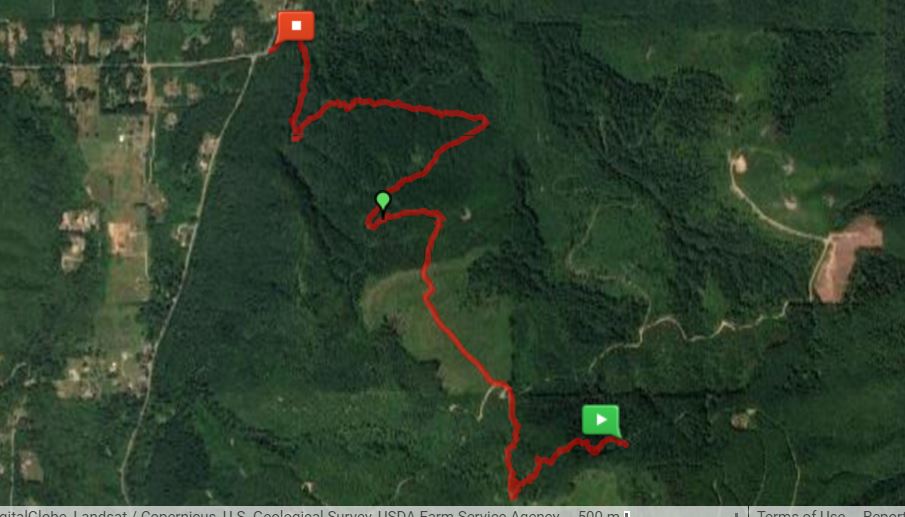
One section of the Rattlesnake Ledge trail

Counting the distance from the car to the trailhead, and using the park's distance from trailhead to summit, I'm going to claim 4.5 miles of hiking. So here are the statistics for today:
Gain: 1,160 feet
Distance: 4.5 miles, 7.2 km
Load: 14 pounds
Stamina: Varied, but overall my timing was good.


July 12, 2017

Twin Falls Again
Statistics:
Distance: 3 miles, 4.8 km
Gain: 400 feet
Load: 13-pound pack
Stamina: Started strong, grew weary toward end of hike. Big nap afterward.

July 13

Alaskan Way via Madison
Statistics:
Distance: 3 miles, 4.8 km
Gain: at least 400 feet, given ups and downs.
Load: 10 pound pack -- carrying two water-filled half-gallon bottles
Stamina: Strong going downhill; weary going up.

July 15

To Alaskan Way and to Umpqua Bank to distribute meals
Statistics:
Distance 4.8 miles, 7.68 km
Elevation gain: 300 feet (using topo map that shows condo at 325 feet;
no elevation gain on Umpqua Bank portion of hiking.
Load: None
Stamina: Good; no hot flashes on uphill portion, but winded once.

Stats for all four hikes:
Distance: 24.48 km
Gain: 2,700 feet

States for year to date:
Distance: 218.66 km
Elevation Gain: 11,510 feet

Saturday, July 8, 2017

Higher up McDonald Mountail


Map My Hike software redeemed itself a little bit July 7, when Roger Matthews, I and Roger's dog, Tucker, took another run at Mt, McDonald yesterday. The map at the left shows where we set out, with my Honda Fit parked on Kent-Kangley road, just south of Kangley.

We started on the usual path, then took a detour when we spotted an alternate route that mountain bikers use extensively. On our return, we stuck to the trail. Outward bound, Map My Hike showed 3.38 miles hiked; the return route showed 3.18. The hike took us 4.5 hours and resulted in an elevation gain of about 1,650 feet.

The route out, and back, and a portion of bike trail

The three images at the left show the outward bound route (starting with green box);  the return route (ending in the red box); and a section of the mountain bike trail that descends to a small foot bridge along the trail. In the maps, the white line shows the trail as indicated by a map overlay, and the red lines shows where we actually walked. The mountain bike portion included some sections that were quite steep and required use of our trekking poles to ascend.

Forest dwelling

Not following the beaten path can yield some special rewards: We discovered a small shelter alongside the mountain bike path where someone had excavated beneath a tree, and reinforced the walls of the dirt "cellar" with wooden beams.

Someone had carved out a cozy home beheath a tree.


A flat, easy portion of the mountain  bike trail.


A little more adventurous portion of the mountain bike trail


A sharp curve on the mountain bike trail


Returning to the regular trail afforded us daylight and some colorful foxgloves.


Latest stats:

Distance: 6.4 miles (10.5 km)
Elevation gain: 1,650

Load: 12 pounds
Total distance for the year: 194.18 km
Total elevation gain for the year: still 8,810 feet


Wednesday, July 5, 2017

To the bank

I set out this morning to Umpqua bank, hauling a backpack of bananas from the Algona Pacific Food Bank with me. Encountered a man at 12th and Union who said he wanted food, but he also wanted a bathroom. He seemed a bit buzzy. I pulled out some bananas and he walked off. I think he was on drugs.

Found one man sleeping in the doorway, another on the grass at Seattle Central, and the usual panhandler at the Walgreens at Pine and Broadway. Made it almost to Dick's Hamburgers when I realized I had forgotten the title to the Fit, which I was going to put in the safety deposit box at the bank. Returned home. Saw a man sitting on a bench where I had seen him earlier. Offered him bananas, but he turned them down as spoiled (he opened one and it was a bit bruised. I had more to offer, but thought better of it.)

Returned home for the title and decided to stay there because of a Scrabble date with a friend on 17th. Used to the time to cull the bananas, putting most in the freezer for future smoothies. Then went on date, picking up a jug of milk along the way, so I was packing a load that included the milk, apple pie, pastries, and several pounds of bananas. Got back home about 4 p.m. and walked to the bank again, arriving just after it closed. I thought it stayed open late, but it closed at five.

Returned home by way of Dick's Hamburgers, where I bought a woman in a wheelchair a cheeseburger, fries and a coke. She said she had been on the street for four years and was injured a few months ago. Gave me an idea for the Web site: What to do if you are injured.

Today's stats:

Distance: 4 miles (6.4 km)
Elevation gain: Not counted

Load: not counted
Total distance for the year: 183.68 km
Total elevation gain for the year: still 7,160 feet