Wednesday, September 4, 2019

Mount Rainier's Plummer Peak with Roger and Tammi

A pika paused his darting for a few moments to munch on a salad.

Washington Trails Association says that the climb to Plummer Peak is a 1,500 elevation gain and the summit is 6,359 feet. I didn't make it to the summit yesterday, Sept. 2. The trail took me along a very steep drop off and I am always uncomfortable with those, particularly when I have a backpack on that shifts my center of gravity. Roger Matthews and Tammi Termann went ahead. I turned back and waited for their return. Ironically, it was Tammi who took a spill on the trail, banging her face and arm slightly and drawing a little blood, but otherwise weathering the storm well.slightly,  The altitude was affecting us a bit, so maybe that was a factor. Using my phone GPS I believe we were hiking above 4,800 feet, and were closing in toward 6,000 feet before I turned back. Even young people we passed on our descent were sweating and moving slowly. WTA says the trip is 4.5 miles, so I feel comfortable claiming 3.5 miles.

At the Grove of the Patriarchs, Tammi climbed among the roots of a fallen tree.

A patriarch yet to fall

On the Plummer Peak hike, a chipmunk prays for a morsel.

At this elevation, trees struggle to survive.

A view of the mountain during the descent

Mushrooms cower together at a switchback, below a menacing field of skree

Near the trailhead we found other mushrooms like this one at various life stages.

Noteworthy moments: 

Sworls on a burl on an old growth log


  • A visit to the Grove of the Monarchs, a must every time you visit Rainier National Park.
  • A big fat marmot browsing below the final ascent to Plummer Peak
  • Several pikas darting around
  • The accidental discovery of what appeared to be blueberries, but were probably blue huckleberries
  • Discovery of some impressive mushrooms
  • Feeling the effects of elevation

Stats for the day:

Distance: 3.5 miles*
Conditions: Clear Sky
Load: 18 pounds
Elevation gain: 1,000 feet 

Statistics, year to date:
Distance: 234.1 miles 
Elevation Gain: 71,178 feet


Fifth Rainier on Mount Si!

Scene near the canal where I gathered and filtered water to drink.

August 26, 2019 --Today I surpassed 70,000 verticle feet for 2019, ascending the equivalent height of Mount Rainier for the fifth time -- my goal for the year. I was not high energy, but I made the summit lookout in three hours. Other noteworthy moments: Learning from a fellow hiker that water flowing straight from the rocks was safe to drink (I still filtered the water from the stream in the "canal" at the early part of the trail.) I got by with one large bottle of water and some trail mix. I had prepared tuna salad, which I finished when I got back home. My feet hurt, but not as much as they might have; I had rolphed them the night before.

A scene by the boardwalk at snag flats, a little past the first mile marker

A scene just above the canal where I filtered drinking water

Two large trees bookend the trail.

Distance: 8 miles*
Conditions: Clear Sky
Load: 18 pounds
Elevation gain: 3,000 feet 

Statistics, year to date:
Distance: 229.6 miles 
Elevation Gain: 70,178 feet -- my Fifth Rainier for the year!


Saturday, August 17, 2019

Mount Ellinor, Lena Lake and a goat on the Olympic Peninsula

View from dining area of Robin Hood Resort at Union, WA

My friend, Tammi Hermann, invited me for a two-night groupon at Robin Hood Resort at Union on Hood Canal, very close to some nice hikes: Mount Ellinor, and Lena Lake, both in the neighborhood of Lake Cushman. We also took the time to identify potential camping locations in nearby state parks.


Our trip took us to the Kitsap peninsula via the Southworth Ferry on the 14th.

A commuter's conundrum expressed on the piling next at the Fauntleroy ferry dock.


We drove to the resort, found the office closed, and then drove  to the Mima Mounds West of Olympia.

Several trees rose from one of the dozens of mounds at the Mima Mounds site.

Trunks of a clutch of maple trees at Potlatch State Park.

The sight that greeted us at the beginning of our Mount Ellinor hike

A friendly part of the Mount Ellinor ascent.

A not-so-friendly part of the Mount Ellinor ascent.

Hikers were invited to pack rebar and logs up the trail for trail maintenance.

Tammy stood beside a recently improved trail that benefited from the logs and rebar.

Back at the resort we dined, attended the resort's open mic night and enjoyed the hot tub. The next morning we rose early and hiked Mount Ellinor by way of Lake Cushman. The climb started steep and ended up to be a scramble up a rocky path that could have led us to the Mountain Goats that soon will be relocated to the Cascades. But the fog was nipping at our heels and I wasn't confident that we could descend without an injury, so I called off the hike within probably 200 yards of where we would encounter the goats.

We were in he neighborhood of 5,000 feet elevation when we turned back. The hot tub was particularly welcome that night because our muscles were a little sore.

On the Lena Lake trail we found what appeared to be a dry waterfall that likely roars in the spring.

On Friday we left early after collecting some sea shells along the beach. We went to Hamma Hamma and discovered the hike to Lena Lake, climbing with what appeared to be improved stamina. I found myself having trouble keeping up with Tammi -- or staying ahead of her. She had worried ahead of time that she was out of shape, but I was impressed with her speed, especially as we descended from Lena Lake at close to 3 mph, as fast as I've ever descended a trail.

One of two log bridges on the Lena Lake Trail.

Cedar logs along the trail, perhaps destined to be split for trail maintenance.


Our destination -- Lena Lake

At Lena Lake, two young interns with Olympic National Forest included us in their survey about how many people knew the proper way to defecate in the forest. One of them, Katie Spires, a University of Washington student, was kind enough to e-mail us a photo of a Mountain Goat at Lena Lake, below. A hiker we met on the trail said the goats would be netted, sedated, and moves to the Cascades.

A mountain goat close to the edge of a cliff overlooking Lena Lake. Photo by Katie Spires.


Tammi at Potlatch Park

Hiking statistics for Ellinor:
Distance: 2.6 miles*
Conditions: Overcast, some foggy mist; higher altitude
Load: 19 pounds
Elevation gain: 1,500 feet 

Hiking statistics for Lena Lake:
Distance: 6 miles*
Conditions: Overcast, very light rain
Load: 19 pounds
Elevation gain: 1,250 feet 

Statistics, year to date:
Distance: 221.6 miles 
Elevation Gain: 67,178 feet
Next Goal: 70,000 feet, my Fifth Rainier. 2.822 feet to go.


Listless leaf left on a log

A tree and its trunk separated by our walking path


Friday, August 9, 2019

Sunrise at Rainier, again

Parking lot, buildings and background at Sunrise, Mount Rainier Aug 8, 2019

I was surprised at my low energy levels today when I was hiking toward Frozen Lake today. Joan Tito also was tired and turned back to wait for me and John Anderson to return later.

Joan. In the background, Dege Peak, where we three hiked last year. (Click link)


We hiked to the lake, then took a different path back and ended up unintentionally separating.  What became clear is that I'm out of shape for 7,000-foot elevations. Later, when we stopped at Mud Mountain Dam, which is several thousand feet lower, our energy levels were fine.

The bank above the route back to Sunrise

The photo below was taken on the return hike. A squirrel ran across the trail then climbed up upon a rock, chewigh vigorously on what appears to be a crust of bread it found along the trail.


Hiking statistics for the day:
Distance: 5 miles*
Conditions: Clear, sunny
Load: 15 pounds
Elevation gain: 500 feet to 6,500 feet +

Statistics, year to date:
Distance: 213 miles 
Elevation Gain: 64,428 feet
Next Goal: 70,000 feet, my Fifth Rainier. 5,572 feet to go.

* This involved both the hike to Frozen lake and the return via a different route, plus additional hiking at Mud Mountain Dam.


Tuesday, August 6, 2019

Oregon Road Trip

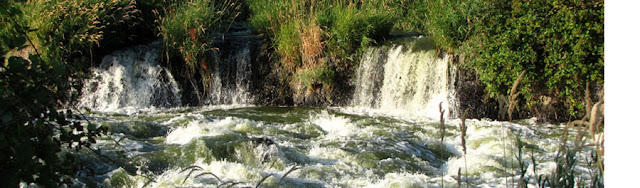
The falls at Klamath Falls (some of them)

This road trip was supposed to include a lot of hiking and camping. I only camped one night and only had one substantial hike, but the trip paid off as I learned about the area of Oregon between Bend and Klamath Falls. I used both a time share and a campground and I learned enough about hiking in the area to plan to return next spring, I think.

The trip took me to Olympia, Portland, Bend, Klamath Falls, Lava Beds National Park, Lake of the Woods, Talent, Crater Lake, and back to Portland. Enroute I visited with my college roommate, Paul Swensson, in Olympia and stayed the first night with Melanie Wood, a friend who lives in Portland. I also stayed with Donna Boehm and her friend, Dave, in Talent, OR.

The only significant climb occurred at Crater Lake, with about 20 pounds on my back and only a 400-foot elevation gain. I found myself stopping to breathe. I need to hike more.

The first full day I was there, Monday, July 29, Donna and David, came to visit. We drove to the Lava beds, located in Northern California. We walked in a lava tube and visited native rock art.

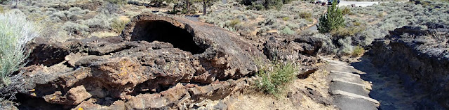
Our first stop took us past a flattened lava tube as we headed to see small "chimneys."

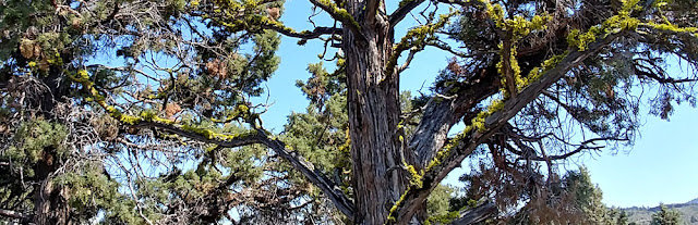
Despite the hot, arid landscape, this desiccated tree supported moss.

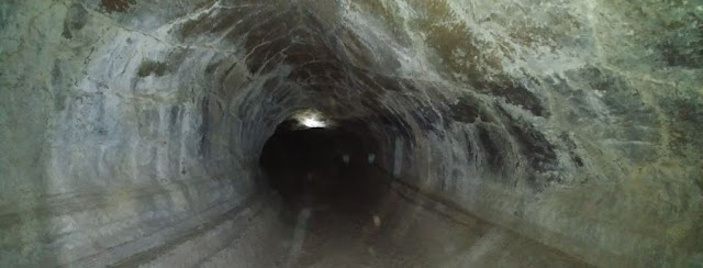
The park reportedly had hundreds of caves, including a lava tube large enough to stand upright in.

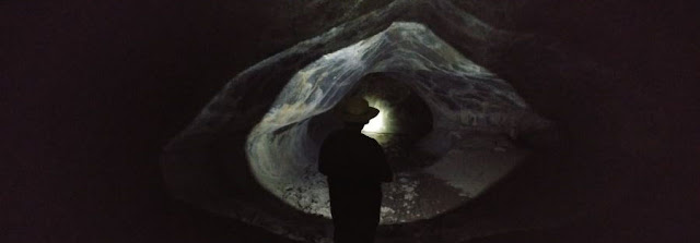
A strong flashlight provided the only illumination for Donna's silhouette.

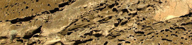
Afterward we visited a cliff whose basaltic exterior showed  where air pockets cooked in the lava.

Indian rock carvings distinguished the base of the cliff.


Bird nests on the cliff wall

Hiking statistics for the trip:
Distance: 4 miles
Conditions: Clear, sunny
Load: 17 pounds
Elevation gain: 400 feet at 7,000 feet elevation

Statistics, year to date:
Distance: 208 miles 
Elevation Gain: 63,928 feet
Next Goal: 70,000 feet, my Fifth Rainier. 6,072 feet to go.


On Tuesday I drove past Mount Shasta, above, to hike to McCloud Falls, below.


On Wednesday I drove past Klamath Lake, which is heavily polluted, to the point where I believe the actual Klamath Falls had been more spectacular before a small dam was installed. Still, the river flowed furiously, but not enough to intimidate a pelican that calmly watched the swirling water from the safety of a small rock in the river (below). I also spied a river otter bounding across a pathway, far too fast to photograph.


Thursday, Aug. 1, was my last day at the time share. I set out for Talent to visit Donna and Dave, stopping enroute to check out Lake of the Woods, with its view of Mount McLoughlin, below.


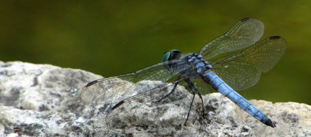
There were lots of dragonflies. This one was at a duck pond in Ashland's theater district.

On Friday I set out for crater lake, camping in a national forest the first night. Then I hiked the 3.6 miles and 400-foot elevation gain to Watchman Peak, a fire lookout above the lake, before heading on to Portland to stay the night with my friend, Melanie Wood.

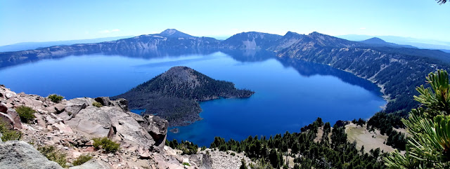
The lake was stunningly blue this day; there was virtually no haze, despite fires in the region.

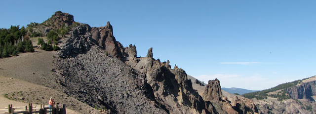
Rough rock formations at one viewpoint above the lake.

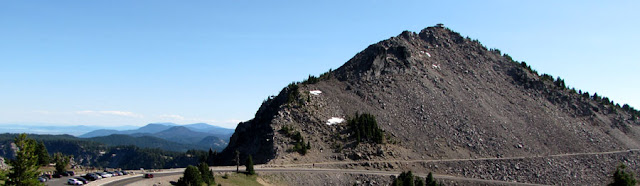
The trail to Watchman Peak, where the fire station can be made out.

The fire lookout station

I exited the North Entrance to Crater Lake National Park enroute to Portland. By happenstance, I pulled over right at the entrance to the trailhead leading to Fall Creek Falls. A better time to visit is in the late spring, when the canyon leading from the falls is a rushing torrent.